Leading Edge Claims Service Unveils LEMA-X: The Next-Generation Evolution of Our Legacy System, LEMA4/4/2024
Leading Edge Claims Service, a leader in the insurance claims management space, is thrilled to unveil LEMA-X, a groundbreaking claims management system designed to replace and surpass our legacy system, LEMA. This launch heralds a new era of innovation, offering enhanced security, superior analytics, and a user-friendly interface, all the result of a year-long endeavor in programming new architecture, framework, and code refinement. This innovative system is designed to meet the evolving needs of the insurance industry, providing unparalleled efficiency and accuracy in claims handling.
Key Features of LEMA-X: Enhanced Security: Leveraging cutting-edge security measures to protect sensitive data and ensure privacy. Superior Analytics: Advanced analytics capabilities that offer deep insights into claims data to provide actionable insights, enabling better decision-making and KPI measures. User-Friendly Interface: A streamlined and intuitive interface that simplifies the claims process for adjusters and clients alike. Scalable Architecture: A robust framework that easily adapts to the growing demands of the business, ensuring seamless scalability. Streamlined Workflow: LEMA-X streamlines the entire claims process, from initial reporting to final settlement. Adjusters, insurers, and policyholders will experience a more efficient and transparent journey. Real-Time Analytics: LEMA-X is at the forefront of data-driven claims management, offering a robust analytics engine that provides actionable insights. With capabilities for real-time tracking and comprehensive trend analysis, our system equips decision-makers with the tools they need to make informed choices swiftly and confidently. Customization: Understand that every claim is unique, LEMA-X allows for flexible customization, adapting to the specific needs of each case. Whether it’s a minor incident or a catastrophic event, our system caters to all scenarios. Integration: LEMA-X can be easily integrated with existing industry-standard platforms such as XactAnalysis, Guidewire, Symbility, and other carrier-specific claim systems. This interoperability ensures a smooth transition for our clients. LEMA-X is the culmination of our commitment to innovation and excellence in claims management,” said Troy Hansen, President of Leading Edge Claims Service. “We’re excited to bring this revolutionary tool to the market, confident that it will set a new standard for efficiency, security, and analytical prowess in the industry.” The launch of LEMA-X is a testament to Leading Edge Claims Service’s dedication to driving progress through technology. As the industry continues to evolve, LEMA-X stands ready to lead the way, delivering the future of claims management today. For more information about LEMA-X and Leading Edge Claims Service, please visit our website at www.LeadingEdgeClaims.com or contact our office at 866-659-4525. About Leading Edge Claims Service: Founded in 2007, Leading Edge Claims Service has established itself as a leader in property claims adjusting and third-party claims administration. With a focus on technology and innovation, the company has consistently delivered end-to-end claims efficiency and scalability, restoring Insured’s lives and earning the trust of carriers and clients alike to continually Lead the Way in Times of Crisis! © 2024 Leading Edge Claims Service. All rights reserved.
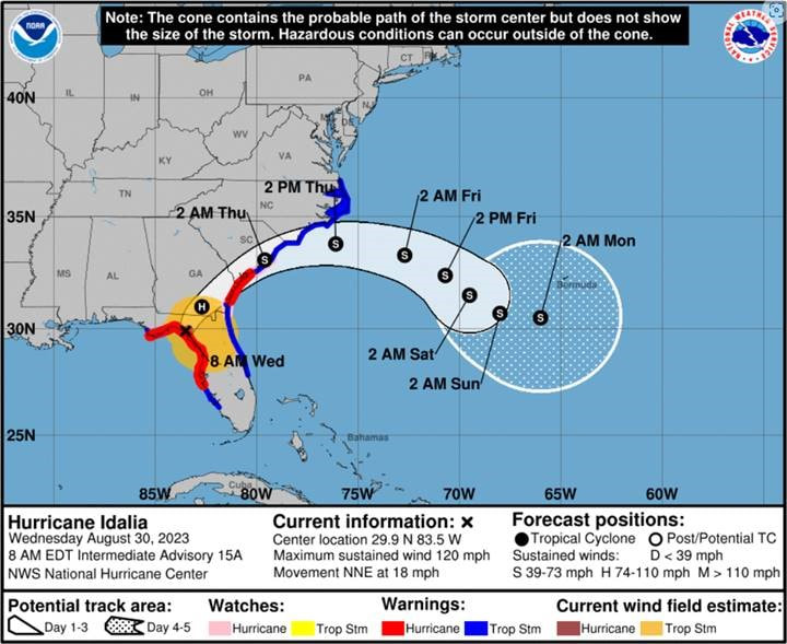
With the late turn of Ian to the east toward Tampa, Leading Edge is requesting and asking for additional commitments to deploy to Florida with plans of being in the Tampa vicinity on October 2, 2022. Leading Edge Claims has contracts with multiple Carriers in Florida that have large PIF counts in the Tamp Bay area. Please see the latest from the Natiaal Hurricane Center.
We will require additional commitments and additional deployments. You must be Florida licensed and have a minimum of 6 months experience. Please let us know your availability for immediate deployment. Retainer fees are available for the Desk, and retainer fess for the Field will be discussed later today. More information will come to those of you with interest. Please reply to this email with your availability and HR will begin processing your deployment. Benefits for Hurricane Ian!
Please reply and let us know if you are available for deployment and a representative of Leading Edge will be reaching out shortly. Desk - $425 - 450 per day, 7 days per week, retainer fees paid for those deployed today and receive claims. Two types of Field Deployments
 TASK Assignment – Contact, enter file note in XA, inspect, prepare estimate and photos, enter file note in XA, complete and connect. That’s it. An adjuster can close 2 of these per day for every one of the full assignments. So, if your fast and like to inspect and close 6-8 claims a day or more, this is the deployment for you.  Please let us know your immediate response by replying/sending an email to hr@leadingedgeclaims.com. If you were forwarded this email, please go to https://www.leadingedgeclaims.com/employment.html and click “Apply Now”, complete the short form app, and we will be reaching out to you.
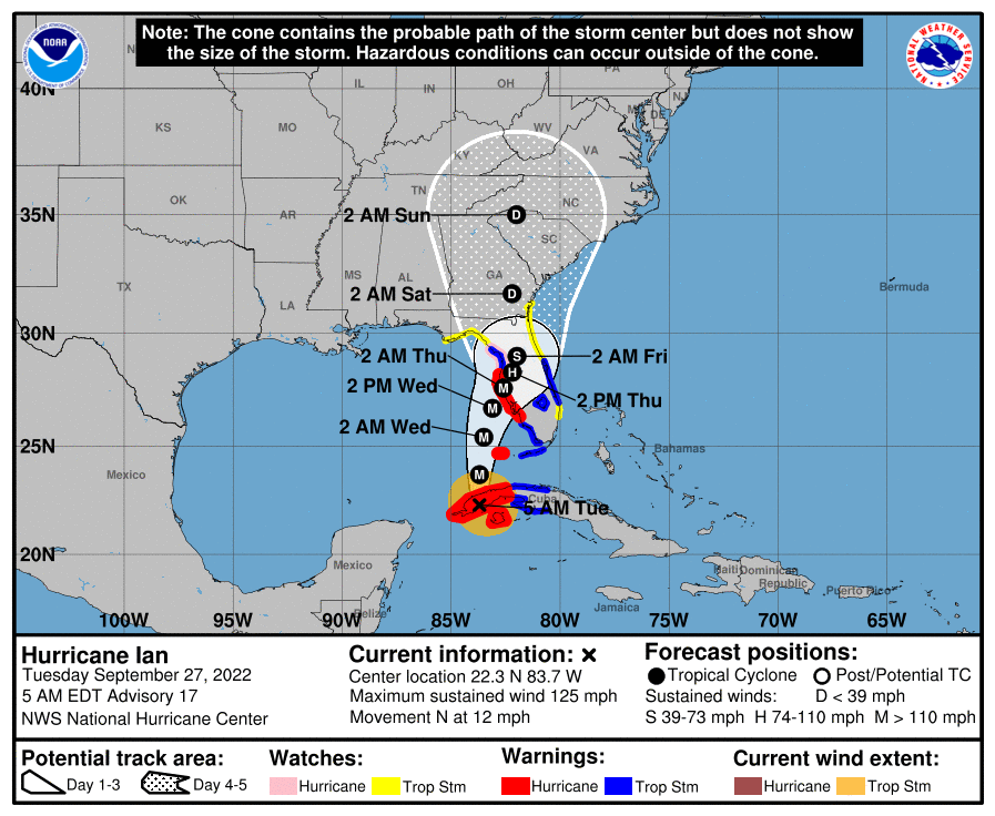
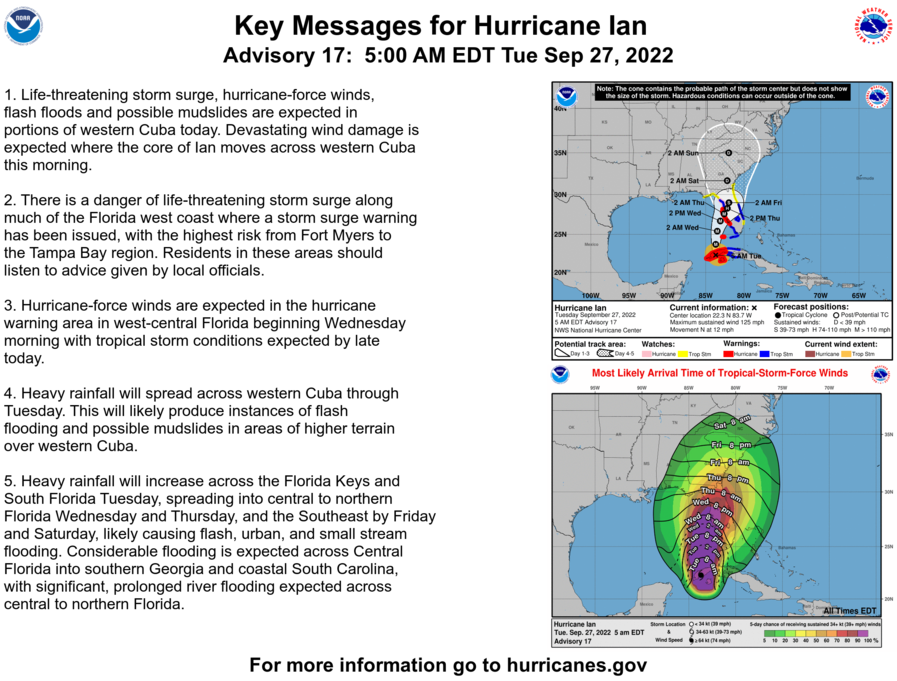
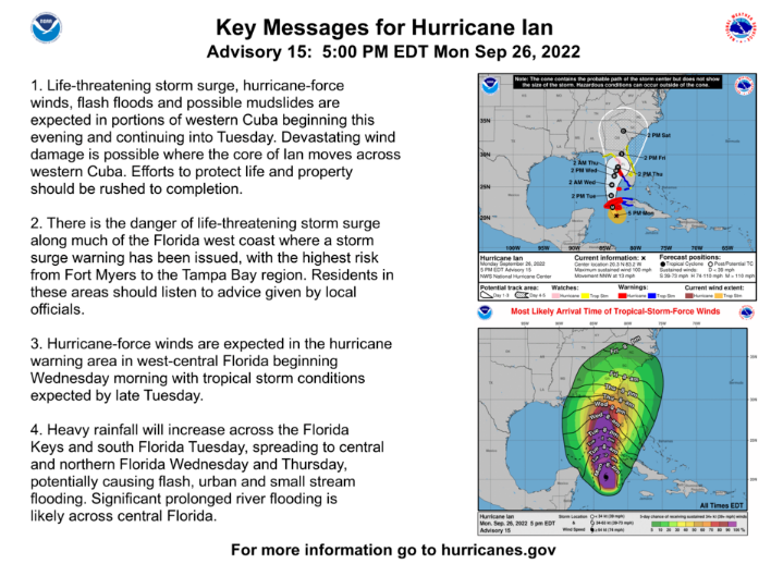
We look forward to working with as many of you as possible. With the track moving towards Tampa, we have started deploying desk adjusters and field adjusters as of this morning. As we "Lead the Way" with our pre-staging/deployment activity, we are prepared and ready for additional deployments as the storm approaches. We will continue getting our adjuster deployed and our desk adjusters set-up throughout the week. Our field adjusters will be on location outside of Tampa on October 2, 2022 and our desk adjusters will be setting up tomorrow for FNOL and other services. Quick Summary of IAN: (Thanks Sam!) Hurricane Ian has strengthened throughout the day today and is now a category 2 hurricane with sustained winds of 100 MPH as it moves north northwest at 13 MPH. Ian is 150 miles southeast of the western tip of Cuba and now is expected to cross over Cuba early tomorrow as a category 3 major hurricane and continue to intensify in the Gulf of Mexico, potential to a category 4, as it continues its turn to the north and eventually northeast. Ian is expected to stall off the coast of west central Florida on Wednesday, which will increase the potential for surge loss along the coast. After this stall it is expected to weaken before approaching landfall in Florida north of Tampa as a likely category 2 hurricane. There is still potential that Ian stays on a more northerly track and skirts the coast and makes eventual landfall in the Big Bend area of Florida or on the panhandle, however the 5PM models are showing more consistently around the north of Tampa landfall scenario. In either case tropical storm and hurricane force winds will be felt all along the west coast of Florida, along with very heavy rains, and potential storm surge of up to 10 feet in the Tampa area and high surge all along the coast. The further north Ian can stay off the coast the better because as it gets north it should be running into less favorable conditions that will help to weaken the system. Tropical storm warnings are in place for southwest Florida and the Florida Keys and hurricane warnings are in place from north of Tampa south to the Ft. Myers area. Many counties around Tampa are calling for mandatory evacuations to begin this afternoon. We’ll continue to monitor and provide updates around potential impacts.
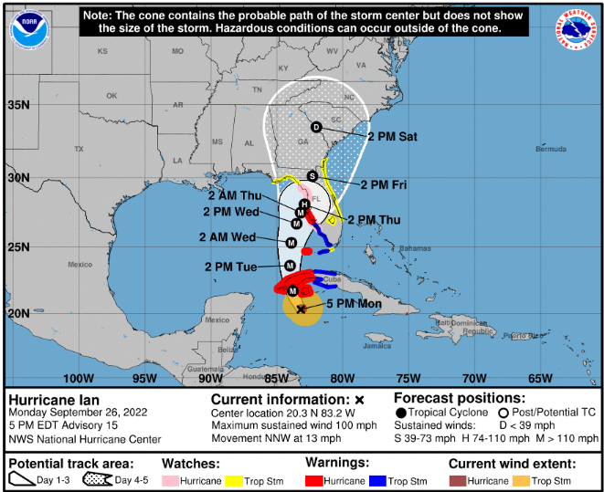
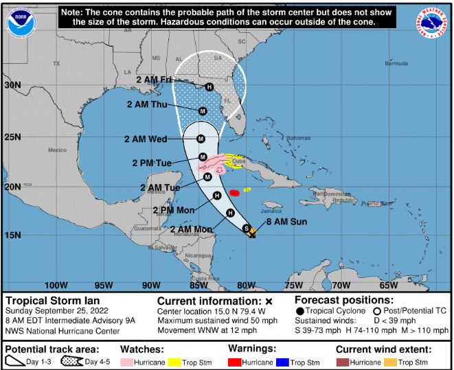
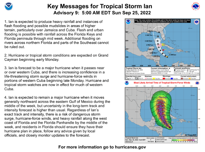
Leading Edge Adjusters are on standby and ready for deployment with our Carriers. We will continue to monitor the track of the storm which will affect the amount of personnel needed. Ian remains a tropical storm this morning with sustained winds of 50 MPH as it moves west northwest at 12 MPH and is around 200 miles southeast of Jamaica. Throughout the day yesterday and this morning models have continued to move Ian’s track to the west, which now has most eventual landfall predictions being from the north of Tampa Bay to all the way across the Florida panhandle. As the NHC notes, there is still a lot of uncertainty in the long term tracks and intensity models. Ian is still disorganized this morning, but models are showing it getting together better through today and tomorrow and starting to quickly strengthen in the very warm waters. Current NHC models are showing Ian being a CAT 3 as it approaches Cuba on Tuesday and as it moves further into the Gulf. As of now models are showing a weakening as it approaches Florida and deals with drier air and increasing shear. Beacon is showing a CAT 1 or tropical storm at landfall and many other models are agreeing with a weaker storm near shore, however hurricane conditions and surge can be expected along the entire east coast of Florida if models hold. As for now there are hurricane warnings in place for Grand Cayman and hurricane watches in place for western Cuba. We’ll need to continue to monitor the models closely throughout the day today.
Leading Edge Claims Service is excited to be a Gold Sponsor at the National PLRB Claims Conference and Insurance Services Expo in San Antonio this year and will be located in Booth 1247. We are looking forward to another PLRB and can't wait to interact with our peers and clients after the conference shut downs due to COVID.   LECS is set up for the 2021 TAMIC Convention and Seminar! It is great to be back in Austin after taking a year off during the COVID-19 pandemic.
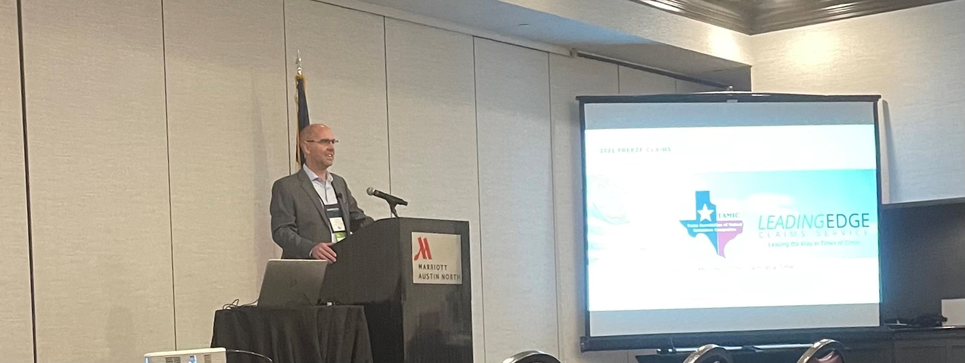
President, Troy Hansen, will be presenting to the TAMIC members tomorrow about the 2021 Texas Freeze! If you are in attendance, stop by and say hi to Troy and our VP of Claims, Blake Mears. 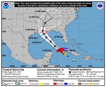 As of 11:00 am, Hurricane Ida is expected to intensify further now to 120mph before landfall. Pressures are falling and Hurricane Hunters are finding the storm structure is improving. Rapid Intensification is likely tomorrow.
Ida is tracking almost the same keeping LA and some of MS in the cone. Landfall later Sunday... with feeder bands reaching parts of the Gulf coast throughout Saturday night into Sunday as it approaches. Adjusters are on standby and mobilization to Louisiana is planned. |
Adjusters |
Company |
|